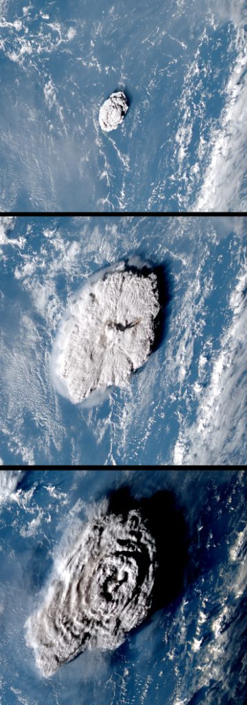
Oxford University researchers have shown the devastating Hunga Tonga–Hunga Haʻapai eruption in January 2022 created the tallest volcanic plume ever recorded. The new analysis has been published in the journal Science. (https://scitechdaily.com/highest-ever-recorded-volcanic-plume-the-hunga-tonga-hunga-haapai-eruption/)
At 57km high (35 miles), the ash cloud generated by the eruption is also the first to have been observed in the mesosphere, a layer of the atmosphere more commonly associated with shooting stars. The previous record-holder, the 1991 eruption of Mount Pinatubo in the Philippines, caused a plume was recorded as 40km high, although accurate satellite images, such as those taken over Tonga, were not available at the time.
The Tonga eruption took place under the sea, around 65km from the country’s main island, causing tsunamis felt as far away as Russia, the United States, and Chile. The waves claimed six lives, including two people in Peru, 10,000km away.
“It’s the first time we’ve ever recorded a volcanic plume reaching the mesosphere. Krakatau in the 1800s might have done as well, but we didn’t see that in enough detail to confirm,” said Dr Simon Proud, a National Center for Earth Observation senior scientist at the University of Oxford and the Science and Technology.
Normally, the height of a volcanic plume can be estimated by measuring the temperature at its top and comparing it to the standard air temperatures found at various altitudes. This is because, in the troposphere, the lowest layer of the Earth’s atmosphere, temperature decreases with height. But, if the eruption is so large the plume penetrates the higher layers of the atmosphere, this method becomes unreliable, as air temperatures begin to increase again with height.
To overcome this problem, the researchers developed a technique based on a phenomenon called ‘the parallax effect’.
This effect can be seen by closing your right eye, and holding out one hand with the thumb raised upwards. If you switch eyes, so your left is closed and your right is open, the thumb will appear to shift slightly against the background. By measuring this apparent change in position, and combining this with the known distance between your eyes, you can calculate the distance between your eyes and your thumb.
The location of the Tonga volcano is covered by three geostationary weather satellites, 36,000km up in space, so the researchers were able to apply the parallax effect to the aerial images these captured. Crucially, during the eruption itself, the satellites recorded images every 10 minutes, enabling the rapid changes in the plume’s trajectory to be documented.
‘Thirty years ago, when Pinatubo erupted, our satellites were nowhere near as good as they are now. They could only scan the earth every 30 minutes. Or maybe even every hour,’ said Dr Proud.
The study, “The January 2022 eruption of Hunga Tonga-Hunga Ha’apai volcano reached the mesosphere” has been published in the journal Science.
The three satellites used to capture and evaluate the eruption were GOES-17 (USA), Himawari-8 (Japan) and GeoKompSat-2A (Korea). The open-access data was processed by the UK’s Jasmin Supercomputer at the Science and Technology Facilities Council’s Rutherford Appleton Lab.

AR Issue #42
The Super Volcano Threat
by John Kettler