Posted on

Singular Sword Sheds Light on Viking Voyages

By Elin Nyberg

A unique Viking Age sword with spectacular ornamentation has been found in Stavanger, Norway. The closest parallel is a sword from the island Eigg in Scotland found in a grave from the 800s.

The sword was found in three pieces by two metal detector enthusiasts, independent of each other, in the Jåttå/Gausel area in Stavanger, already renowned for the grave of the so-called ‘Gausel queen.’ It would have been one of the most spectacularly ornamented and heaviest types of swords from the Viking Age. The blade is missing, but the hilt has unique details in gold and silver, and exquisite details not previously known.


Only about 20 such swords have been found in Norway – out of a total of around 3000 Viking sword finds.
The sword is currently under conservation at the Museum of Archaeology at the University of Stavanger. It is still difficult to see the details in the hilt, but the décor includes gilded elements of the typical animal styles found during the Iron and Viking Age, between ca 550 and 1050.


The hilt also contains geometrical figures in silver, made with the so-called niello technique. This means that a metallic mixture of sorts was used to make black stripes in the silver.


Both ends of the crossguard are formed as animal heads.


This particular type of sword has been found in both Eastern and Western Europe. The few swords of this type found in Norway were most likely imported.


“But it is possible to imagine that copies of these types of swords were made by very competent sword-smiths in Norway,” points out Zanette Glorstad, one of the researchers.


“The location of the find, close to the Gausel queen, means that we have to take a new look at the entire Jåttå/Gausel area,” says Håkon Reiersen, researcher at the Museum of Archaeology in Stavanger.


“The outstanding collection of imported spectacular finds connected to both men and women in this area shows that this has been an important hub for the contact across the North Sea,” he says.


The metal detector enthusiasts immediately turned in their finds to the Cultural heritage management as Norwegian law demands. This ensured that the Museum of Archaeology at the University of Stavanger immediately could take care of the parts and start the conservation work.


The sword will be exhibited at the Museum of Archaeology at the University of Stavanger when the conservation work is finished.

https://www.uis.no/en/research/unique-sword-casts-new-light-on-viking-voyages-across-the-north-sea

AR #129

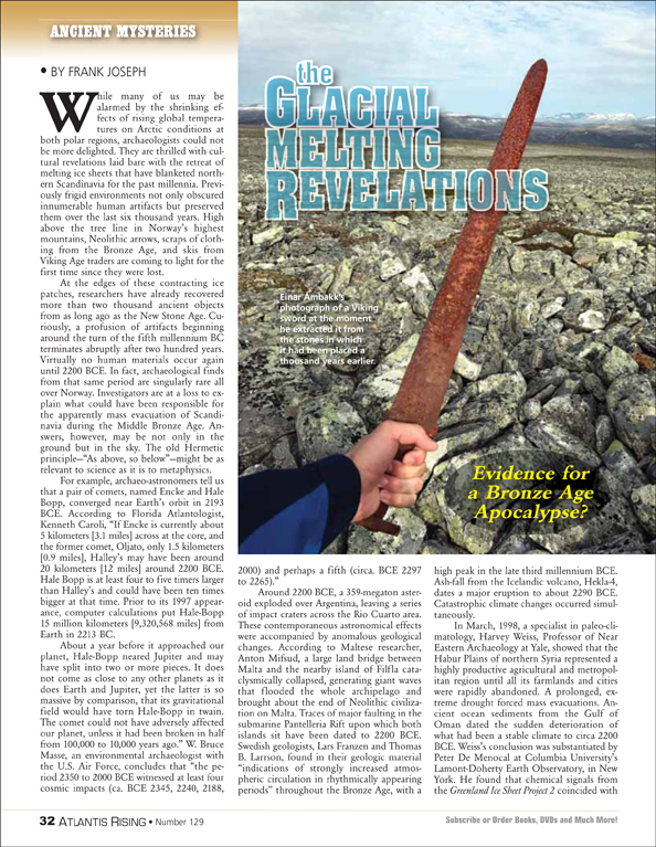
The Glacial Melting Revelations

by Frank Joseph
 

Posted on

Why the Vikings Left Greenland

One of the great mysteries of late medieval history is why did the Norse, who had established successful settlements in southern Greenland in 985, abandon them in the early 15th century?


The consensus view has long been that colder temperatures, associated with the Little Ice Age, helped make the colonies unsustainable. However, new research, led by the University of Massachusetts Amherst and published recently in Science Advances, upends that old theory. It wasn’t dropping temperatures that helped drive the Norse from Greenland, but drought.


When the Norse settled in Greenland on what they called the Eastern Settlement in 985, they thrived by clearing the land of shrubs and planting grass as pasture for their livestock. The population of the Eastern Settlement peaked at around 2,000 inhabitants, but collapsed fairly quickly about 400 years later.


For decades, anthropologists, historians and scientists have thought the Eastern Settlement’s demise was due to the onset of the Little Ice Age, a period of exceptionally cold weather, particularly in the North Atlantic, that made agricultural life in Greenland untenable.


However, as Raymond Bradley, University Distinguished Professor of geosciences at UMass Amherst and one of the paper’s co-author, points out. Bradley and his colleagues traveled to a lake called Lake 578, which is adjacent to a former Norse farm and close to one of the largest groups of farms in the Eastern Settlement. There, they spent three years gathering sediment samples from the lake, which represented a continuous record for the past 2,000 years.
What was discovered, said was that, while the temperature barely changed over the course of the Norse settlement of southern Greenland, it became steadily drier over time. Norse farmers had to overwinter their livestock on stored fodder, and even in a good year the animals were often so weak that they had to be carried to the fields once the snow finally melted in the spring. Under conditions like that, the consequences of drought would have been severe. An extended drought, on top of other economic and social pressures, may have tipped the balance just enough to make the Eastern Settlement unsustainable.

AR #123, “Lost City of the Arctic,”

by Frank Joseph

Posted on

The Vikings Were Here First

The Map May Have Been Fake, but the Journey Was Real

The history of the Viking presence in North America has gotten a lot more interesting. Both those who believe the Vikings were here before Columbus, and those who deny it, have something to cheer about.

In September, the famous Vinland map, once claimed to be from the 15th century and depicting the North American coast, was declared a fake. Yale University experts not only claimed to have detected modern components in the ink of the parchment map, but also evidence that the map makers were intentionally attempting to deceive. Ironically though, The case for a Viking presence almost half a millennium before Columbus, suddenly became much stronger. Reuters reported in October, that a newly developed dating technique used on wood fragments from Norse layers at L’Anse aux Meadows Viking settlement near Hay Cove, Newfoundland, has authoritatively determined that  the site was occupied, a full thousand years ago, long before Columbus.

So while scholars, long convinced that our continent was hermetically sealed off from the outside world before the arrival of Christopher Columbus, are—Vinland map notwithstanding—left with proof of a pre columbian presence.

Bound in a mid-15th Century history of the Mongols, the so-called “Vinland Map” was purportedly re-drawn from a two-hundred-year older compilation of several, earlier maps, apparently indicating extensive knowledge of what is now the eastern United States going back a thousand years. The land mass portrayed farthest to the left, identified as Vinilanda Insula, encompassed an area from Maine in the north to the Carolinas in the south; from the Atlantic Seaboard to the Susquehanna River in central Pennsylvania.

The new analysis revealed that a titanium compound used in inks first produced in the 1920s was used in the map’s lines and text.

“The Vinland Map is a fake,” said Raymond Clemens, curator of early books and manuscripts at Yale’s Beinecke Rare Book & Manuscript Library, which houses the map. “There is no reasonable doubt here. This new analysis should put the matter to rest”  (https://news.yale.edu/2021/09/01/analysis-unlocks-secret-vinland-map-its-fake).

The new study also uncovered evidence that the map deception was intentional. A Latin inscription on its back, possibly a bookbinder’s note guiding the assembly of the Speculum—an authentic medieval volume and likely source of the map’s calfskin parchment—is overwritten with modern ink to appear like instructions for binding the map within the genuine 15th-century manuscript.

Nevertheless, long before Columbus crossed the Atlantic, eight timber-framed buildings covered in sod placed on a terrace above a peat bog and stream at the northern tip of Canada’s island of Newfoundland, would provide irrefutable evidence that the Vikings reached the New World first. Previously, the date when the Vikings journeyed to L’Anse aux Meadows had remained unclear—but no more.

Scientists used new dating technique referencing a long-ago solar storm to establish that the settlement was occupied in 1021 AD, exactly a millennium ago and 471 years before the first voyage of Columbus. The method was used on three pieces of wood cut for the settlement, all pointing to the same year. The study was published in the journal Nature.(https://www.nature.com/articles/s41586-021-03972-8)

The Viking voyage, it is agreed, represented multiple milestones for humankind. The settlement offers, say the scientists, the earliest-known evidence of a transatlantic crossing. It also shows where they believe the globe was finally encircled by humans. There is evidence, however, that Columbus himself was guided by maps predating his own voyages by thousands of years.