Posted on

How did Earth get its water?

This image has an empty alt attribute; its file name is ai-free.png

Our planet’s water could have originated from interactions between the hydrogen-rich atmospheres and magma oceans of the planetary embryos that comprised Earth’s formative years, according to new work from Carnegie Science’s Anat Shahar and UCLA’s Edward Young and Hilke Schlichting. Their findings, which could explain the origins of Earth’s signature features, are published in Nature.

For decades, what researchers knew about planet formation was based primarily on our own Solar System. Although there are some active debates about the formation of gas giants like Jupiter and Saturn, it is widely agreed upon that Earth and the other rocky planets accreted from the disk of dust and gas that surrounded our Sun in its youth.

As increasingly larger objects crashed into each other, the baby planetesimals that eventually formed Earth grew both larger and hotter, melting into a vast magma ocean due to the heat of collisions and radioactive elements. Over time, as the planet cooled, the densest material sank inward, separating Earth into three distinct layers—the metallic core, and the rocky, silicate mantle and crust.

However, the explosion of exoplanet research over the past decade informed a new approach to modeling the Earth’s embryonic state.

“Exoplanet discoveries have given us a much greater appreciation of how common it is for just-formed planets to be surrounded by atmospheres that are rich in molecular hydrogen, H2, during their first several million years of growth,” Shahar explained. “Eventually these hydrogen envelopes dissipate, but they leave their fingerprints on the young planet’s composition.”

Using this information, the researchers developed new models for Earth’s formation and evolution to see if our home planet’s distinct chemical traits could be replicated.

Using a newly developed model, the Carnegie and UCLA researchers were able to demonstrate that early in Earth’s existence, interactions between the magma ocean and a molecular hydrogen proto-atmosphere could have given rise to some of Earth’s signature features, such as its abundance of water and its overall oxidized state.  

The researchers used mathematical modeling to explore the exchange of materials between molecular hydrogen atmospheres and magma oceans by looking at 25 different compounds and 18 different types of reactions—complex enough to yield valuable data about Earth’s possible formative history, but simple enough to interpret fully.
Interactions between the magma ocean and the atmosphere in their simulated baby Earth resulted in the movement of large masses of hydrogen into the metallic core, the oxidation of the mantle, and the production of large quantities of water.


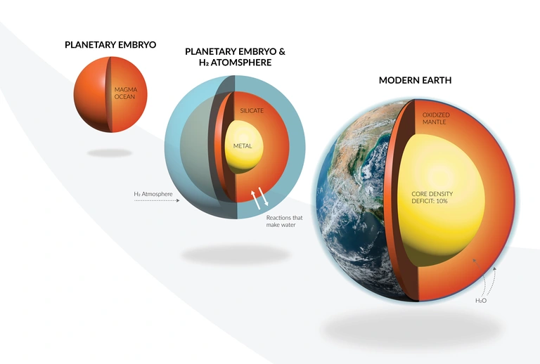
Caption: An illustration showing how some Earth’s signature features, such as its abundance of water and its overall oxidized state could potentially be attributable to  interactions between the molecular hydrogen atmospheres and magma oceans on the planetary embryos that comprised Earth’s formative years. Illustration by Edward Young/UCLA and Katherine Cain/Carnegie Institution for Science.


Even if all of the rocky material that collided to form the growing planet was completely dry, these interactions between the molecular hydrogen atmosphere and the magma ocean would generate copious amounts of water, the researchers revealed. Other water sources are possible, they say, but not necessary to explain Earth’s current state.
“This is just one possible explanation for our planet’s evolution, but one that would establish an important link between Earth’s formation history and the most common exoplanets that have been discovered orbiting distant stars, which are called Super-Earths and sub-Neptunes,” Shahar concluded.

This project was part of the interdisciplinary, multi-institution AEThER project, initiated and led by Shahar, which seeks to reveal the chemical makeup of the Milky Way galaxy’s most common planets—Super-Earths and sub-Neptunes—and to develop a framework for detecting signatures of life on distant worlds. Funded by the Alfred P. Sloan Foundation, this effort was developed to understand how the formation and evolution of these planets shape their atmospheres. This could—in turn—enable scientists to differentiate true biosignatures, which could only be produced by the presence of life, from atmospheric molecules of non-biological origin.

“Increasingly powerful telescopes are enabling astronomers to understand the compositions of exoplanet atmospheres in never-before-seen detail,” Shahar said. “AEThER’s work will inform their observations with experimental and modeling data that, we hope, will lead to a foolproof method for detecting signs of life on other worlds.”

AR #123

What Does Water Remember”

by Jeane Manning

Posted on

Ancient Plans for Mysterious Desert Mega Structures

This image has an empty alt attribute; its file name is ai-free.png

Although human constructions have modified natural spaces for millennia, few plans or maps predate the period of the literate civilizations of Mesopotamia and Ancient Egypt. Researchers have now been able to identify engravings in Jordan and Saudi Arabia as the oldest known true-to-scale construction plans in human history. The 8,000 to 9,000-year-old engravings depict so-called desert dragons—kilometer long prehistoric megastructures used to trap animals.

Researchers from the French research organization “Centre national de la recherche scientifique” (CNRS), together with Prof. Dr. Frank Preusser from the University of Freiburg, have now been able to identify engravings in Jordan and Saudi Arabia as the oldest known true-to-scale construction plans in human history. “Conclusions can be drawn from the findings about the people of the time. The ability to transfer a large space to a small, two-dimensional plan represents a milestone in intelligent behavior,” explains Preusser. The results, which were published in mid-May in the scientific journal PLOS ONE, should help to understand how desert dragons were conceived and built.

Both finds are representations of nearby desert dragons engraved with stone tools. First sighted from aircrafts in the 1920s, desert dragons, up to five kilometers long, consist of stone walls that converge in a complex bounded by pits. As archaeologists have been able to determine in recent years, they were used for large-scale trapping of wild animals. In Jordan, there are eight desert dragons in the area of Jibal al-Khasabiyeh. There, the researchers found a depiction engraved in stone that measures 80 by 32 cm, its age is about 9,000 years. At Jebel az-Zilliyat in Saudi Arabia, two visible pairs of dragons are found three and a half kilometres apart. Here, too, a scaled engraving dating back about 8,000 years was discovered with a total length of 382 cm and a width of 235 cm.

Plans of large structures have so far only been attested by rough representations, in stark contrast to the precision of the engravings of al-Khashabiyeh and az-Zilliyat. The question of their exact use and how they were implemented, especially due to the difficulty of grasping the entire complex from the ground, remains for the time being the secret of the people by whom they were created.

AR #109

Once Upon a Time in Inner Space

by Martin Ruggles

Posted on

Third of Milky Way Planets May Be Able to Host Life

This image has an empty alt attribute; its file name is ai-free.png

In a new analysis based on the latest telescope data, astronomers have discovered that a third of the planets around the most common stars in the galaxy could be in a goldilocks orbit close enough, and gentle enough, to hold onto liquid water—and possibly harbor life.

The remaining two-thirds of the planets around these ubiquitous small stars are likely roasted by gravitational tides, sterilizing them.

University of Florida astronomy professor Sarah Ballard and doctoral student Sheila Sagear published their findings the week of May 29 in the Proceedings of the National Academy of Sciences. Ballard and Sagear have long studied exoplanets, those worlds that orbit stars other than the sun (https://www.pnas.org/doi/10.1073/pnas.2217398120https://www.pnas.org/doi/10.1073/pnas.2217398120).

“I think this result is really important for the next decade of exoplanet research, because eyes are shifting toward this population of stars,” Sagear said. “These stars are excellent targets to look for small planets in an orbit where it’s conceivable that water might be liquid and therefore the planet might be habitable.”

Our familiar, warm, yellow sun is a relative rarity in the Milky Way. By far the most common stars are considerably smaller and cooler, sporting just half the mass of our sun at most. Billions of planets orbit these common dwarf stars in our galaxy.

Scientists think that liquid water is required for life to evolve on other planets, like it did on Earth. Because these dwarf stars are cooler, any planets would have to huddle very close to their star to draw enough warmth to host liquid water. However, these close orbits leave the planets susceptible to extreme tidal forces caused by the star’s gravitational effect on the planets.

Sagear and Ballard measured the eccentricity – how oval the orbit is –  of a sample of more than 150 planets around these dwarf stars, which are about the size of Jupiter. If a planet orbits close enough to its star, at about the distance that Mercury orbits the sun, an eccentric orbit can subject it to a process known as tidal heating. As the planet is stretched and deformed by changing gravitational forces on its irregular orbit, friction heats it up. At the extreme end, this could bake the planet, removing all chance for liquid water.

“It’s only for these small stars that the zone of habitability is close enough for these tidal forces to be relevant,” Ballard said.

Data came from NASA’s Kepler telescope, which captures information about exoplanets as they move in front of their host stars. To measure the planets’ orbits, Ballard and Sagear focused especially on how long the planets took to move across the face of the stars. Their study also relied on new data from the Gaia telescope, which measured the distance to billions of stars in the galaxy.

“The distance is really the key piece of information we were missing before that allows us to do this analysis now,” Sagear said.

AR #109

Once Upon a Time in Inner Space

by Martin Ruggles

Posted on

Giant Water Reservoir Discovered on the Moon

The surface of the moon contains a new source of water embedded in millions of microscopic glass beads. Someday all that water, scientists say, might help astronauts produce drinking water, breathable air and even rocket fuel. The new findings come from a Chinese rover that spent two weeks on the moon in 2020.

Evidence of lunar water had only recently emerged from data collected by NASA’s Stratospheric Observatory for Infrared Astronomy (SOFIA). A large telescope on a modified Boeing 747SP jet was able to study the moon from above 99 percent of Earth’s atmospheric water vapor, permitting precise infrared observations without needing any space-based facilities. Another NASA paper published in the same issue of Nature Astronomy has studied permanently shadowed areas—known as cold traps—on the moon in which extremely low temperatures could freeze and preserve water essentially indefinitely, allowing it, over geologic time, to accumulate significant deposits. (https://www.nature.com/articles/s41550-020-01222-x)

Volatile elements and compounds, such as water, say researchers, are crucial to geological processes and will be vital for future in-situ resource utilization on the Moon. Thus, say scientists, it is important to understand the abundance of these elements, their location (i.e., locked in minerals or at depth as ice), and evolution through time on the Moon. Spacecraft missions such as the Lunar Reconnaissance Orbiter have demonstrated that the lunar surface harbors water in at least some form. However, the origin of this water and its distribution across the lunar surface remains largely unknown. Compounding this is the fact that volatile elements likely migrate around the surface of the Moon and can be lost to space. An as-yet-undiscovered reservoir in the near-surface is required to replenish surface water and maintain the lunar water cycle.

In the recent Chinese discovery, Huicun He and colleagues from the Chinese Academy of Sciences analyzed 117 glass beads from a lunar soil sample collected by the Chang’e 5 robotic arm and returned to Earth on December 16, 2020. These beads showed water-poor cores but had elevated water abundances in their rims. This trend correlated with changing hydrogen isotope composition (the ratio of hydrogen to deuterium) from core to rim. This can be explained by the inward diffusion of water derived from the solar wind (primarily composed of pure hydrogen). The researchers also noted that one bead showed water loss at the outermost rim and suggested that this records water loss during daily surface temperature fluctuations.

Modeling-based estimates indicate that the amount of water that these glass beads could contribute to the lunar regolith is as much as 2.7 × 10¹⁴ kg. The researchers conclude, lunar glass beads might therefore provide the needed reservoir to maintain the lunar water cycle and act as a buffer for the global and daily variations of water abundance on the lunar surface.

AR #68

Does NASA Know Something We Don’t?

by John Kettler

Posted on

Attila and the Huns Attacked Rome for Water

Hunnic peoples migrated westward across Eurasia, switched between farming and herding, and became violent raiders in response to severe drought in the Danube frontier provinces of the Roman empire, a new study argues.

Hungary has just experienced its driest summer since meteorological measurements began, devastating the country’s usually productive farmland. Archaeologists now suggest that similar conditions in the 5th century may have encouraged animal herders to become raiders, with devastating consequences for the Roman empire.


The study, published in the Journal of Roman Archaeology, argues that extreme drought spells from the 430s – 450s CE disrupted ways of life in the Danube frontier provinces of the eastern Roman empire, forcing Hunnic peoples to adopt new strategies to ‘buffer against severe economic challenges’ (https://www.cambridge.org/core/journals/journal-of-roman-archaeology/article/role-of-drought-during-the-hunnic-incursions-into-centraleast-europe-in-the-4th-and-5th-c-ce/C036810C421F7D04C2F6985E6B548F20).


The authors, Associate Professor Susanne Hakenbeck from Cambridge’s Department of Archaeology and Professor Ulf Büntgen from the University’s Department of Geography, came to their conclusions after assessing a new tree ring-based hydroclimate reconstruction, as well as archaeological and historical evidence.


The Hunnic incursions into eastern and central Europe in the 4th and 5th centuries CE have long been viewed as the initial crisis that triggered the so-called ‘Great Migrations’ of ‘Barbarian Tribes’, leading to the fall of the Roman empire. But where the Huns came from and what their impact on the late Roman provinces actually was unclear.


New climate data reconstructed from tree rings by Prof Büntgen and colleagues provides information about yearly changes in climate over the last 2000 years. It shows that Hungary experienced episodes of unusually dry summers in the 4th and 5th centuries. Hakenbeck and Büntgen point out that climatic fluctuations, in particular drought spells from 420 to 450 CE, would have reduced crop yields and pasture for animals beyond the floodplains of the Danube and Tisza.


Büntgen said: “Tree ring data gives us an amazing opportunity to link climatic conditions to human activity on a year-by-year basis. We found that periods of drought recorded in biochemical signals in tree-rings coincided with an intensification of raiding activity in the region.”


Recent isotopic analysis of skeletons from the region, including by Dr Hakenbeck, suggests that Hunnic peoples responded to climate stress by migrating and by mixing agricultural and pastoral diets.


Hakenbeck said: “If resource scarcity became too extreme, settled populations may have been forced to move, diversify their subsistence practices and switch between farming and mobile animal herding. These could have been important insurance strategies during a climatic downturn.”


But the study also argues that some Hunnic peoples dramatically changed their social and political organization to become violent raiders.


Hunnic attacks on the Roman frontier intensified after Attila came to power in the late 430s. The Huns increasingly demanded gold payments and eventually a strip of Roman territory along the Danube. In 451 CE, the Huns invaded Gaul and a year later they invaded northern Italy.


Traditionally, the Huns have been cast as violent barbarians driven by an “infinite thirst for gold”. But, as this study points out, the historical sources documenting these events were primary written by elite Romans who had little direct experience of the peoples and events they described.


“Historical sources tell us that Roman and Hun diplomacy was extremely complex,” Dr Hakenbeck said. “Initially it involved mutually beneficial arrangements, resulting in Hun elites gaining access to vast amounts of gold. This system of collaboration broke down in the 440s, leading to regular raids of Roman lands and increasing demands for gold.”
The study argues that if current dating of events is correct, the most devastating Hunnic incursions of 447, 451 and 452 CE coincided with extremely dry summers in the Carpathian Basin.


Hakenbeck said: “Climate-induced economic disruption may have required Attila and others of high rank to extract gold from the Roman provinces to keep war bands and maintain inter-elite loyalties. Former horse-riding animal herders appear to have become raiders.”


Historical sources describe the Huns at this time as a highly stratified group with a military organization that was difficult to counter, even for the Roman armies.


The study suggests that one reason why the Huns attacked the provinces of Thrace and Illyricum in 422, 442, and 447 CE was to acquire food and livestock, rather than gold, but accepts that concrete evidence is needed to confirm this. The authors also suggest that Attila demanded a strip of land ‘five days’ journey wide’ along the Danube because this could have offered better grazing in a time of drought.


“Climate alters what environments can provide and this can lead people to make decisions that affect their economy, and their social and political organization,” Hakenbeck said. “Such decisions are not straightforwardly rational, nor are their consequences necessarily successful in the long term.”


“This example from history shows that people respond to climate stress in complex and unpredictable ways, and that short-term solutions can have negative consequences in the long term.”


By the 450s CE, just a few decades of their appearance in central Europe, the Huns had disappeared. Attila himself died in 453 CE.
 
https://www.cam.ac.uk/research/news/drought-encouraged-attilas-huns-to-attack-the-roman-empire-tree-rings-suggest

AR #79

Romans in America

by Frank Joseph

Posted on

Harvesting Untapped Fresh Water

By Lois Yoksoulian

An almost limitless supply of fresh water exists in the form of water vapor above Earth’s oceans, yet remains untapped, researchers say. A new study from the University of Illinois Urbana-Champaign is the first to suggest an investment in new infrastructure capable of harvesting oceanic water vapor as a solution to limited supplies of fresh water in various locations around the world.

The study, led by civil and environmental engineering professor and Prairie Research Institute executive director Praveen Kumar, evaluated 14 water-stressed locations across the globe for the feasibility of a hypothetical structure capable of capturing water vapor from above the ocean and condensing it into fresh water – and do so in a manner that will remain feasible in the face of continued climate change.


Kumar, graduate student Afeefa Rahman and atmospheric sciences professor Francina Dominguez published their findings in the journal Nature Scientific Reports (https://www.nature.com/articles/s41598-022-24314-2)
“Water scarcity is a global problem and hits close to home here in the U.S. regarding the sinking water levels in the Colorado River basin, which affects the whole Western U.S.,” Kumar said. “However, in subtropical regions, like the Western U.S., nearby oceans are continuously evaporating water because there is enough solar radiation due to the very little cloud coverage throughout the year.”


Previous wastewater recycling, cloud seeding and desalination techniques have met only limited success, the researchers said. Though deployed in some areas across the globe, desalination plants face sustainability issues because of the brine and heavy metal-laden wastewater produced – so much so that California has recently rejected measures to add new desalination plants.


“Eventually, we will need to find a way to increase the supply of fresh water as conservation and recycled water from existing sources, albeit essential, will not be sufficient to meet human needs. We think our newly proposed method can do that at large scales,” Kumar said.


The researchers performed atmospheric and economic analyses of the placement of hypothetical offshore structures 210 meters in width and 100 meters in height.


Through their analyses, the researchers concluded that capturing moisture over ocean surfaces is feasible for many water-stressed regions worldwide. The estimated water yield of the proposed structures could provide fresh water for large population centers in the subtropics.


One of the more robust projections of climate change is that dry regions will get drier, and wet areas will get wetter. “The current regions experiencing water scarcity will likely be even drier in the future, exacerbating the problem,” Dominguez said. “And unfortunately, people continue moving to water-limited areas, like the Southwestern U.S.”
However, this projection of increasingly arid conditions favors the new ocean vapor-harvesting technology.


“The climate projections show that the oceanic vapor flux will only increase over time, providing even more fresh water supply,” Rahman said. “So, the idea we are proposing will be feasible under climate change. This provides a much needed and effective approach for adaptation to climate change, particularly to vulnerable populations living in arid and semi-arid regions of the world.”


The researchers said one of the more elegant features of this proposed solution is that it works like the natural water cycle.


“The difference is that we can guide where the evaporated water from the ocean goes,” Dominguez said. “When Praveen approached me with this idea, we both wondered why nobody had thought about it before because it seemed like such an obvious solution. But it hasn’t been done before, and I think it is because researchers are so focused on land-based solutions – but our study shows other options do, in fact, exist.”

https://news.illinois.edu/view/6367/833959034

AR #104

Global Drying

by Susan Martinez, Ph.D.

Posted on

Water Found in Ancient Moon Volcanoes

Billions of years ago, a series of volcanic eruptions broke loose on the moon, blanketing hundreds of thousands of square miles of the orb’s surface in hot lava. Over the eons, that lava created the dark blotches, or maria, that give the face of the moon its familiar appearance today.

New research suggests that volcanoes may have left another lasting impact on the lunar surface: sheets of ice that dot the moon’s poles and, in some places, could measure dozens or even hundreds of feet thick.

“We envision it as a frost on the moon that built up over time,” said Andrew Wilcoski, lead author of the new study and a graduate student in the Department of Astrophysical and Planetary Sciences (APS) and the Laboratory for Atmospheric and Space Physics (LASP) at CU Boulder.

He and his colleagues published their findings this month in The Planetary Science Journal.

The researchers drew on computer simulations, or models, to try to recreate conditions on the moon long before complex life arose on Earth. They discovered that ancient moon volcanoes spewed huge amounts of water vapor, which then settled onto the surface—forming stores of ice that may still be hiding in lunar craters. If any humans had been alive at the time, they may even have seen a sliver of that frost near the border between day and night on the moon’s surface.

It’s a potential bounty for future moon explorers who will need water to drink and process into rocket fuel, said study co-author Paul Hayne. 

“It’s possible that 5 or 10 meters below the surface, you have big sheets of ice,” said Hayne, assistant professor in APS and LASP.

Temporary atmospheres
The new study adds to a growing body of evidence suggesting that the moon may be awash in a lot more water than scientists once believed. In a 2020 study, Hayne and his colleagues estimated that nearly 6,000 square miles of the lunar surface could be capable of trapping and hanging onto ice—mostly near the moon’s north and south poles.
Where all that water came from in the first place is unclear.

 “There are a lot of potential sources at the moment,” Hayne said.

Volcanoes could be a big one.
The planetary scientist explained that from 2 to 4 billion years ago, the moon was a chaotic place. Tens of thousands of volcanoes erupted across its surface during this period, generating huge rivers and lakes of lava, not unlike the features you might see in Hawaii today—only much more immense.
“They dwarf almost all of the eruptions on Earth,” Hayne said. 

Recent research from scientists at the Lunar and Planetary Institute in Houston shows that these volcanoes likely also ejected towering clouds made up of mostly carbon monoxide and water vapor. These clouds then swirled around the moon, potentially creating thin and short-lived atmospheres.

That got Hayne and Wilcoski wondering: Could that same atmosphere have left ice on the lunar surface, a bit like frost forming on the ground after a chilly fall night? 

Forever ice
To find out, the duo and Margaret Landis, a research associate at LASP, set out to try to put themselves onto the surface of the moon billions of years ago. 

The team used estimates that, at its peak, the moon experienced one eruption every 22,000 years, on average. The researchers then tracked how volcanic gases may have swirled around the moon, escaping into space over time. And, they discovered, conditions may have gotten icy.

According to the group’s estimates, roughly 41% of the water from volcanoes may have condensed onto the moon as ice. 

“The atmospheres escaped over about 1,000 years, so there was plenty of time for ice to form,” Wilcoski said.
There may have been so much ice on the moon, in fact, that you could, conceivably, have spotted the sheen of frost and thick, polar ice caps from Earth. The group calculated that about 18 quadrillion pounds of volcanic water could have condensed as ice during that period. That’s more water than currently sits in Lake Michigan. And the research suggests that much of that lunar water may still be present today.

Those space ice cubes, however, won’t necessarily be easy to find. Most of that ice has likely accumulated near the moon’s poles and may be buried under several feet of lunar dust, or regolith. 

“We really need to drill down and look for it,” he said.


Atlantis Rising Magazine #126

Vast Reserves of Water Found on the Moon


Posted on

Humans in North Atlantic Before Vikings

Faroes Settled Centuries Earlier

New evidence from the bottom of a lake in the remote North Atlantic Faroe Islands indicates that an unknown band of humans settled there around 500 AD—some 350 years before the Vikings, who up until recently have been thought to have been the first human inhabitants. The settlers may have been Celts who crossed rough, unexplored seas from what are now Scotland or Ireland. The findings appear today in the journal Communications Earth & Environment.

The Faroes are a small, rugged archipelago about midway between Norway and Iceland, some 200 miles northwest of Scotland. Towering cliffs dominate the coasts; buffeted by strong winds and cloudy weather, the rocky landscape is mostly tundra. There is no evidence that Indigenous people ever lived there, making it one of the planet’s few lands that remained uninhabited until historical times. Past archaeological excavations have indicated that seafaring Vikings first reached them around 850 AD, soon after they developed long-distance sailing technology. The settlement may have formed a stepping stone for the Viking settlement of Iceland in 874, and their short-lived colonization of Greenland, around 980.

The bed of this lake on the island of Eysturoy contains a sediment layer laid down around 500 AD that documents the first arrival of sheep, and thus humans, on the archipelago. (Raymond Bradley/UMass Amherst)

The new study, led by scientists at Columbia University’s Lamont-Doherty Earth Observatory, is based on lake sediments containing signs that domestic sheep suddenly appeared around 500, well before the Norse occupation. Previously, the islands did not host any mammals, domestic or otherwise; the sheep could have arrived only with people. The study is not the first to assert that someone else got there first, but the researchers say it clinches the case.

In the 1980s, researchers determined that Plantago lanceolata, a weed commonly associated with disturbed areas and pastures and often used as an indicator of early human presence in Europe, showed up in the Faroes around 2200 B.C. At the time, this was deemed possible evidence of human arrival. However, seeds could have arrived on the wind, and the plant does not need human presence to establish itself. Likewise, studies of pollen taken from lake beds and bogs show that some time before the Norse period, woody vegetation largely disappeared—possibly due to persistent chewing by sheep, but also possibly due to natural climatic changes.

Some Medieval texts suggest that Irish monks reached the islands by around 500. For one, St. Brendan, a famous and far-traveled early Irish navigator, was said to have set out across the Atlantic with comrades from 512 to 530, and supposedly found a land dubbed the Isle of the Blessed. Later speculations and maps say that this was the Faroes—or the far southerly Azores, or the Canary Islands—or that Brendan actually reached North America. There is no proof for any of this. Centuries later, in 825, the Irish monk and geographer Dicuil wrote that he had learned that hermits had been living in some unidentified northern islands for at least 100 years. Again, later speculations landed on on the Faroes, but there was never any proof.

Faroese sheep have been a staple of the culture for centuries, and are found nearly everywhere on the islands. (William D’Andrea/Lamont-Doherty Earth Observatory)

The first physical evidence of early occupation came with a 2013 study in the journal Quaternary Science Reviews, which documented two patches of burnt peat containing charred barley grains found underneath the floor of a Viking longhouse on the Faroese island of Sandoy. The researchers dated the grains to somewhere between 300 and 500 years before the Norse; barley was not previously found on the island, so someone must have brought it. For many archaeologists, this constituted firm evidence of pre-Viking habitation. However, others wanted to see some kind of corroboration before declaring the case closed.

The researchers in the new study employed a non-archaeological approach. In a small vessel, they sailed out onto a lake near the village of Eiði, site of an ancient Viking locale on the island of Eysturoy. Here, they dropped weighted open-ended tubes to the bottom to collect muck—sediments dropped year by year and built up over millennia, forming a long-term environmental record. The cores penetrated down about 9 feet, recording some 10,000 years of environmental history. The scientists had started out hoping to better understand the climate around the time of the Viking occupation, but came up with a surprise.

Starting at 51 centimeters (20 inches) down in the sediments, they found signs that large numbers of sheep had suddenly arrived, most likely some time between 492 and 512, but possibly as early as 370. The telltale signs: identifiable fragments of sheep DNA, and two distinctive types of lipids produced in sheep digestive systems—so-called fecal biomarkers. (The  researchers also found bits of human DNA in the same layers, but suspect modern contamination during handling of the samples.) A layer of ash deposited from a known Icelandic volcano eruption in 877 helped them reliably date the sediment sequences below.

“We see this as putting the nail in the coffin that people were there before the Vikings,” said lead author Lorelei Curtin, who did the research as a grad student at Lamont-Doherty. She noted that while the Faroes look rugged and wild today, practically every square inch of vegetation has been chewed up by Faroese sheep, a staple of the Faroese diet that are found nearly everywhere.

Researchers William D’Andrea (left) and Gregory de Wet load sediment cores taken from the lake bed. (Nicholas Balascio/College of William & Mary)

Beyond the earlier discovery of barley grains, no one has yet found physical remains of pre-Norse people, but the researchers say this is unsurprising. The Faroes contain very few sites suitable for settlement, mainly flat areas at the heads of protected bays where the Norse would have built over earlier habitations. On the other hand, “You see the sheep DNA and the biomarkers start all at once. It’s like an off-on switch,” said Lamont-Doherty paleoclimatologist William D’Andrea, who co-led the study. He points out that the markers correspond well with the Irish monks’ accounts. But, he said, “Those early writings are tenuous—it’s all circumstantial.”

So, who were these early settlers? D’Andrea and Curtin speculate that they could have been Celts, though not necessarily monks. For one, many Faroese place names derive from Celtic words, and ancient, though undated, Celtic grave markings dot the islands. Also, DNA studies of the modern Faroese show that their paternal lineages are mainly Scandinavian, while their maternal lineages are mainly Celtic. Other regions in the north Atlantic show this asymmetry—male Viking settlers are thought to have brought Celtic brides with them—but the Faroes have the highest level of maternal Celtic ancestry, suggesting an existing Celtic population that preceded the Vikings.

Kevin Edwards, an archaeologist and environment researcher at Scotland’s University of Aberdeen, and coauthor of the 2013 barley-grains paper, said the new study “has produced convincing and exciting evidence from another island within the archipelago” of earlier human occupation. He added: “Is similar evidence to be found in Iceland, where similar arguments are made for a pre-Norse presence, and for which tantalizingly similar archaeological, pollen-analytical and human DNA are forthcoming?”

The other authors of the study are Nicholas Balascio of the College of William & Mary; Sabrina Shirazi and Beth Shapiro of the University of California, Santa Cruz; Gregory de Wet and Raymond Bradley of the University of Massachusetts, Amherst; and Jostein Bakke of the University of Bergen, Norway. Lorelei Curtin is now a postdoctoral researcher at the University of Wyoming. The research is the outcome of a collaborative project awarded by the Division of Behavioral and Cognitive Sciences of the U.S. National Science Foundation to Columbia University, UMass Amherst, and William & Mary.

Issue #130
Searching for Antila and Hyperborea

Posted on

How Mars Lost its Oceans

New Experiments May Explain Loss of Magnetic Field

It has long been known that Mars once had oceans due in part to a protective magnetic field similar to Earth’s. However, the magnetic field disappeared, and new research may finally be able to explain why. Researchers recreated conditions expected in the core of Mars billions of years ago and found that the behavior of the molten metal thought to be present likely gave rise to a brief magnetic field that was destined to fade away.

Whether it’s because of science fiction or the fact that you can see it with your own eyes from Earth, Mars has captured the imagination of people for centuries. It’s one of the closest planets to us and has been studied with all manner of scientific instruments aboard the various unmanned space probes that have explored it and continue to do so. Yet, despite this, there are some big unanswered questions about Mars — the answers to which could even shed light on our own distant past and future, given that Earth, Mars and all our neighboring planets were born of the same cosmic stuff.

Some big questions about Mars have already been answered. For example, we know that many visible features of Mars are proof it used to have oceans and a protective magnetic field. But one question in particular had been on the mind of Professor Kei Hirose from the University of Tokyo’s Department of Earth and Planetary Science: There must have been a magnetic field around Mars, so why was it there at all, and why was it there so briefly? Compelled to answer this question, a team led by Ph.D. student Shunpei Yokoo in the Hirose lab explored a novel way to test something so distant from us in both time and space.

“Earth’s magnetic field is driven by inconceivably huge convection currents of molten metals in its core. Magnetic fields on other planets are thought to work the same way,” said Hirose. “Though the internal composition of Mars is not yet known, evidence from meteorites suggests it is molten iron enriched with sulphur. Furthermore, seismic readings from NASA’s InSight probe on the surface tell us Mars’ core is larger and less dense than previously thought. These things imply the presence of additional lighter elements such as hydrogen. With this detail, we prepare iron alloys that we expect constitute the core and subject them to experiments.”

The experiment involved diamonds, lasers, and an unexpected surprise. Yokoo made a sample of material containing iron, sulphur and hydrogen, Fe-S-H, which is what he and his team expect the core of Mars was once made from. They placed this sample between two diamonds and compressed it while heating it with an infrared laser. This was to simulate the estimated temperature and pressure at the core. Sample observations with X-ray and electron beams allowed the team to image what was going on during melting under pressure, and even map how the composition of the sample changed during that time.

“We were very surprised to see a particular behavior that could explain a lot. The initially homogeneous Fe-S-H separated out into two distinct liquids with a level of complexity that has not been seen before under these kinds of pressures,” said Hirose. “One of the iron liquids was rich in sulphur, the other rich in hydrogen, and this is key to explaining the birth and eventually death of the magnetic field around Mars.”

The liquid iron rich in hydrogen and poor in sulphur, being less dense, would have risen above the denser sulphur-rich, hydrogen-poor liquid iron, causing convection currents. These currents, similar to those on Earth, would have driven a magnetic field capable of maintaining hydrogen in an atmosphere around Mars, which in turn would have allowed water to exist as a liquid. However, it was not to last. Unlike the Earth’s internal convection currents which are extremely long lasting, once the two liquids had fully separated, there would have been no more currents to drive a magnetic field. And when that happened, hydrogen in the atmosphere was blown out to space by solar wind, leading to the breakdown of water vapor and eventually the evaporation of the Martian oceans. And this would all have taken place about 4 billion years ago.

“With our results in mind, further seismic study of Mars will hopefully verify the core is indeed in distinct layers as we predict,” said Hirose. “If that is the case, it would help us complete the story of how the rocky planets, including Earth, formed, and explain their composition. And you might be thinking that the Earth could one day lose its magnetic field as well, but don’t worry, that won’t happen for at least a billion years.”

A slice of Mars. The three stages the researchers think the core of Mars underwent 4 billion years ago. Only during the early stage of separation would there have been an appreciable magnetic field. © 2022 Yokoo et al.

Liquid-liquid separation. Electron microprobe images show in detail the strange texture of the two iron alloy liquids. Liquids that separate in such a way are said to be immiscible. © 2022 Yokoo et al.

Papers

Shunpei Yokoo, Kei Hirose, Shoh Tagawa, Guillaume Morard & Yasuo Ohishi, “Stratification in planetary cores by liquid immiscibility in Fe-S-H,” Nature Communications: February 3, 2022, doi:10.1038/s41467-022-28274-z .
Link (Publication)

Issue #107
Ancient Nukes on Mars?


Posted on

Water in the Valles Marineris

As everyone knows, SpaceX entrepreneur Elon Musk plans to make humanity a multi-planetary species. In December, his celebrated ambition to colonize Mars got a big boost.

Until now, the conventional view of most Mars researchers on the availability of water for colonists from Earth, has been focussed on the poles, where massive deposits of water ice have been located. Unfortunately, the polar regions are also the coldest and most inhospitable that visitors from Earth might face, dropping to as low as 221 degrees below zero F. By contrast, areas near the equator, which bask in relatively temperate conditions–as high as 70 degrees F on a summer day–were thought to be lacking in much water. Picking the best site for a human landing on Mars, presented mission planners with a very difficult dilemma: should they go for the best weather, or the most water?

Now, thanks to a new discovery by the European Space Agency’s (ESA) ExoMars Orbiter, we have learned that an enormous canyon near the Martian equator, the Valles Marineris, likely contains vast quantities of water ice just below the surface, similar to permafrost on Earth —in fact, according to scientists, covering an estimated forty percent of over fifteen thousand square miles. Suddenly, the prospect of actually colonizing the red planet, looks a lot more realistic.

According to ESA data from the Trace Gas Orbiter’s (TGO) Fine-Resolution Epithermal Neutron Detector (FREND) instrument, unexpectedly high levels of hydrogen were found. Combined with oxygen, hydrogen makes water, which is the essential component for life on Earth, and, perhaps, as it may yet exist on Mars. The TGO survey focussed on a large region known as Candor Chaos, in the virtual center of the Valles Marineris on the Martian equator. More than 2,500 miles long, 10 times longer and five times deeper than the Grand Canyon of Arizona, the Valles Marineris is the largest canyon in the solar system. If it were on Earth, it could reach from New York to California.

Unlike the barren deserts previously explored by robotic probes from Earth, the scenery of Candor Chaos, could present visitors not only with some spectacular scenery, but maybe, some other, previously little-considered mysteries as well. Not only is it closer than previously considered sites to the Cydonia plain, made famous for the purported ‘Face on Mars,’ the area has at least one anomalous structure that has drawn some serious attention.

In a paper published in 2017 by the Journal of Space Exploration, researchers  George J. Haas, et al, studied a large three-sided pyramidal shape photographed by ‪Mars Global Surveyor (image E06-00269) and other spacecraft, in the Western Region of Candor Chasma. According to the paper’s abstract, in the 1970s the structure caught the attention of world renowned astronomer Carl Sagan, who was so intrigued by the 3-sided pyramidal structure, that he presented the image at the Royal Institution in London during his Christmas Lecture in 1977. Sagan also featured the image in his 1980 book and television series Cosmos in which he commented; ‪“The largest Mars pyramids… are much larger than the pyramids of Sumer, Egypt and Mexico. With the ancient eroded shape, they could be small hills, sandblasted for centuries, but they need ‪to be viewed from nearby.” Perhaps now they will be (https://www.tsijournals.com/articles/threesided-pyramidal-formation-in-the-western-region-of-candor-chasma-13507.html).

Given the right circumstances, water on Mars, we now know, could hold more oxygen than previously believed, theoretically enough to support aerobic respiration. A team led by scientists at Caltech and the Jet Propulsion Laboratory (JPL), has calculated that if liquid water exists on Mars, it could—under specific conditions—contain more oxygen than previously thought possible. According to the model, the levels could even theoretically exceed the threshold needed to support simple aerobic life.

“Oxygen is a key ingredient when determining the habitability of an environment, but it is relatively scarce on Mars,” said Woody Fischer, professor of geobiology at Caltech and a co-author of a Nature Geoscience paper on the findings, which was published in October 2019.  Their paper was entitled “O2 solubility in Martian near-surface environments and implications for aerobic life.” (https://authors.library.caltech.edu/88984/)

Scientists have speculated that the flowing surface water, in an environment where the temperatures are far below freezing, indicates that there might very well be large aquifers—pools of liquid water—beneath, but close to, the surface.

Clearly, many mind-blowing discoveries lie ahead.