Posted on

1918 Flu Pandemic Targeted the Poor After All

This image has an empty alt attribute; its file name is ai-free.png

New analysis of the remains of victims of the 1918 influenza pandemic, which killed an estimated 50 million people worldwide, contradicts the widespread belief the flu disproportionately impacted healthy young adults.

According to Konya News service, archaeologist Hasan Uguz, head of excavations of the Konya Museums Directorate, scientists have determined that “the local Christian people used the underground city in the 8th century to protect themselves from the raids that lasted for 150 years.” Yet while conventional archaeology may assign the city to the middle ages, the possibility that the structure may have been occupied during the Roman era, does little to explain just when the giant complex was actually designed and engineered. The builders were far more capable than Christian refugees of the Roman era are believed to be, and clearly had much greater resources at their disposal.
Elderly people who had lived in the area all their lives, says Uguz, played in the tunnels as children, and knew a very large underground city was nearby, but no one suspected just how enormous it was, and scientists did not believe the underground tunnels, corridors, and rooms could spread over such an extensive area. The human capacity and exact size of the complex is expected to become clear as the work progresses, but, for now, how people of Sarayini actually lived remains a mystery.
Since 2012, many astonishing subterranean sites in Turkey have drawn the attention of archaeologists from around the world. So far, over two hundred such cities have been reported, but most have not yet been adequately explored, and it seems certain that many more await discovery. Much of the recent digging has been guided by Semih Istanbulluoglu, an archaeologist from Ankara University. In December, 2015, Istanbulluoglu told Turkey’s Hurriyet Daily News, that scientists believe, pending further laboratory work, at least some of the underground cities will date back to even before the Hittites in the second millennium BC.
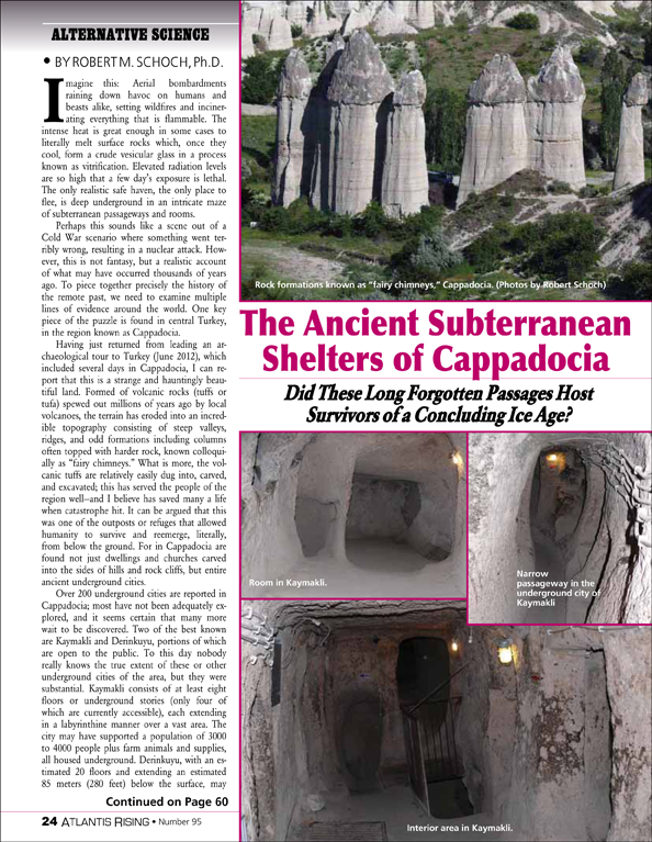
To this day nobody really knows the true extent of the area’s underground cities, but they are certainly substantial. Celebrated Boston University geologist Robert Schoch, in a report for Atlantis Rising Magazine, (AR #95) described two of the cities, “Kaymakli consists of at least eight floors or underground stories (only four of which are currently accessible), each extending in a labyrinthine manner over a vast area. The city may have supported a population of 3,000 to 4,000 people plus farm animals and supplies, all housed underground. Derinkuyu, with an estimated twenty floors and extending an estimated 85 meters (280 feet) below the surface may have supported anywhere from a few thousand to 10,000 people plus their livestock and goods. And the underground cities may not have been entirely isolated from one another. Kaymakli and Derinkuyu are less than a dozen kilometers (seven and a half miles) from each other and there are reports of a tunnel that may connect them.”
Cappadocia’s astonishing underground cities, Schoch believes, though, in all probability, occupied many times since, were originally built around the end of the last ice age, twelve to thirteen thousand years ago.

AR #90

“The Paraffin Mold Experiments,”

by Michael E Tymn

Posted on

Another Enormous Underground City Unearthed in Turkey

Archaeologists Struggle to Explain Sarayini

This image has an empty alt attribute; its file name is ai-free.png

Covering at least 20,000 square meters, the newly discovered underground city of Sarayini, is one of the largest of its kind yet found in Central Anatolia. Included are large domestic areas with adjoining galleries, room-like living spaces, water wells, furnaces, workshops, chimneys, oil lamps for lighting, cellars, warehouses, ventilation, and many—as yet un-investigated—areas.

According to Konya News service, archaeologist Hasan Uguz, head of excavations of the Konya Museums Directorate, scientists have determined that “the local Christian people used the underground city in the 8th century to protect themselves from the raids that lasted for 150 years.” Yet while conventional archaeology may assign the city to the middle ages, the possibility that the structure may have been occupied during the Roman era, does little to explain just when the giant complex was actually designed and engineered. The builders were far more capable than Christian refugees of the Roman era are believed to be, and clearly had much greater resources at their disposal.
Elderly people who had lived in the area all their lives, says Uguz, played in the tunnels as children, and knew a very large underground city was nearby, but no one suspected just how enormous it was, and scientists did not believe the underground tunnels, corridors, and rooms could spread over such an extensive area. The human capacity and exact size of the complex is expected to become clear as the work progresses, but, for now, how people of Sarayini actually lived remains a mystery.
Since 2012, many astonishing subterranean sites in Turkey have drawn the attention of archaeologists from around the world. So far, over two hundred such cities have been reported, but most have not yet been adequately explored, and it seems certain that many more await discovery. Much of the recent digging has been guided by Semih Istanbulluoglu, an archaeologist from Ankara University. In December, 2015, Istanbulluoglu told Turkey’s Hurriyet Daily News, that scientists believe, pending further laboratory work, at least some of the underground cities will date back to even before the Hittites in the second millennium BC.
To this day nobody really knows the true extent of the area’s underground cities, but they are certainly substantial. Celebrated Boston University geologist Robert Schoch, in a report for Atlantis Rising Magazine, (AR #95) described two of the cities, “Kaymakli consists of at least eight floors or underground stories (only four of which are currently accessible), each extending in a labyrinthine manner over a vast area. The city may have supported a population of 3,000 to 4,000 people plus farm animals and supplies, all housed underground. Derinkuyu, with an estimated twenty floors and extending an estimated 85 meters (280 feet) below the surface may have supported anywhere from a few thousand to 10,000 people plus their livestock and goods. And the underground cities may not have been entirely isolated from one another. Kaymakli and Derinkuyu are less than a dozen kilometers (seven and a half miles) from each other and there are reports of a tunnel that may connect them.”
Cappadocia’s astonishing underground cities, Schoch believes, though, in all probability, occupied many times since, were originally built around the end of the last ice age, twelve to thirteen thousand years ago.

AR #95

“The Ancient Subterranean Shelters of Cappadocia,”

by Robert M. Schoch, Ph.D.

Posted on

The Advanced Astronomy of Prehistoric Cave Art

This image has an empty alt attribute; its file name is ai-free.png

A ‘Lunar calendar’ found in the caves at Lascaux, France “may predate equivalent record-keeping systems by at least 10,000 years.” Hunter-gatherers from the ice age, it seems, had a primitive writing system which has now been uncovered by Ben Bacon, an amateur archaeologist, who concluded that the 20,000-year-old markings recorded the mating cycles of local animals.

Working with academic experts Bacon has published his research in a paper for the Cambridge Archaeological Journal (https://www.sciencedirect.com/science/article/abs/pii/S0262407923000039?via%3Dihub).

Such special meaning in cave art symbols, however, has already been studied, and recently, as reported in Atlantis Rising Magazine. In 1996 at the Return to the Source conference at the University of Delaware, independent American researcher Frank Edge announced that he had identified certain celestial formations incorporated into cave drawings at Lascaux. Edge’s evidence including identification of the Pleiades and other stars in a series of black dots placed over the most prominent bull in the famed ‘Hall of the Bulls’ and was described by reporter Laura Lee in an article for Atlantis Rising in February of 1997. Then in 2000, the BBC also took notice of evidence for an ancient hidden language in the Lascaux designs, albeit without crediting the original discoverer.

Dr. David Whitehouse, BBC’s News Online science editor wrote at the time that “a prehistoric map of the night sky has been discovered on the walls of the famous painted caves at Lascaux in central France.” His story went on to describe the “map” thought to date back 16,500 years. Credited by the BBC with making the discovery, was Dr. Michael Rappenglueck, a German professor from the University of Munich, who argued that the map represented the three bright stars known as the summer triangle as well as the Pleiades. A similar pattern of stars was shown on a cave painting in Spain. The maps, said Rappenglueck show that our ancestors were more sophisticated than many believe, revealing that considerable scientific knowledge accompanied their legendary painting skill.

The significance of the art in the Lascaux caves may be greater than even the BBC suspects. More recent groundbreaking research on very ancient cave paintings in Lascaux and elsewhere, underscores the point that ancient people had a very advanced knowledge of astronomy.

A study produced in 2018 by researchers at the University of Edinburg, documents that artworks at sites across Europe, are not simply depictions of wild animals, as was previously supposed. Instead, analysis showed, the animal symbols represent star constellations in the night sky, and are used to represent dates and mark events such as comet strikes. They reveal that, perhaps as far back as 40,000 years ago, humans kept track of time using knowledge of how the position of the stars slowly changes over thousands of years. The findings suggest that long before the Greeks, ancient people understood a phenomenon known as the ‘precession of the equinoxes’. The ‘precession’ tracks in reverse order, the twelve 2150-year cycles, corresponding to the signs of the zodiac (i.e., the Age of Aquarius), also known as the “Great Year”.

The study was published in Athens Journal of History in 2018. “Early cave art shows,” said Dr Martin Sweatman, of the University of Edinburgh, and the lead author, “that people had advanced knowledge of the night sky within the last ice age. Intellectually, they were hardly any different to us today.”

AR #101

Neanderthal & Civilization

by Martin Ruggles

Posted on

Miraculous “Dark Earth” Intentionally Created by Ancient Amazonians

This image has an empty alt attribute; its file name is ai-free.png

The Amazon river basin is known for its immense and lush tropical forests, so one might assume that the Amazon’s land is equally rich. In fact, the soils underlying the forested vegetation, particularly in the hilly uplands, are surprisingly infertile. Much of the Amazon’s soil is acidic and low in nutrients, making it notoriously difficult to farm.

But over the years, archaeologists have dug up mysteriously black and fertile patches of ancient soils in hundreds of sites across the Amazon. This “dark earth” has been found in and around human settlements dating back hundreds to thousands of years. And it has been a matter of some debate as to whether the super-rich soil was purposefully created or a coincidental byproduct of these ancient cultures.

Now, a study led by researchers at MIT, the University of Florida, and in Brazil aims to settle the debate over dark earth’s origins. The team has pieced together results from soil analyses, ethnographic observations, and interviews with modern Indigenous communities, to show that dark earth was intentionally produced by ancient Amazonians as a way to improve the soil and sustain large and complex societies.

“If you want to have large settlements, you need a nutritional base. But the soil in the Amazon is extensively leached of nutrients, and naturally poor for growing most crops,” says Taylor Perron, the Cecil and Ida Green Professor of Earth, Atmospheric and Planetary Sciences at MIT. “We argue here that people played a role in creating dark earth, and intentionally modified the ancient environment to make it a better place for human populations.”

And as it turns out, dark earth contains huge amounts of stored carbon. As generations worked the soil, for instance by enriching it with scraps of food, charcoal, and waste, the earth accumulated the carbon-rich detritus and kept it locked up for hundreds to thousands of years. By purposely producing dark earth, then, early Amazonians may have also unintentionally created a powerful, carbon-sequestering soil.

“The ancient Amazonians put a lot of carbon in the soil, and a lot of that is still there today,” says co-author Samuel Goldberg, who performed the data analysis as a graduate student at MIT and is now an assistant professor at the University of Miami. “That’s exactly what we want for climate change mitigation efforts. Maybe we could adapt some of their indigenous strategies on a larger scale, to lock up carbon in soil, in ways that we now know would stay there for a long time.”

The study was just published in Science Advances. Other authors include former MIT postdoc and lead author Morgan Schmidt, anthropologist Michael Heckenberger of the University of Florida, and collaborators from multiple institutions across Brazil. https://www.science.org/doi/10.1126/sciadv.adh8499).

In their current study, the team synthesized observations and data that Schmidt, Heckenberger, and others had previously gathered, while working with Indigenous communities in the Amazon since the early 2000s,  with new data collected in 2018-19. The scientists focused their fieldwork in the Kuikuro Indigenous Territory in the Upper Xingu River basin in the southeastern Amazon. This region is home to modern Kuikuro villages as well as archaeological sites where the ancestors of the Kuikuro are thought to have lived. Over multiple visits to the region, Schmidt, then a graduate student at the University of Florida, was struck by the darker soil around some archaeological sites.
“When I saw this dark earth and how fertile it was, and started digging into what was known about it, I found it was a mysterious thing — no one really knew where it came from,” he says.

Schmidt and his colleagues began making observations of the modern Kuikuro’s practices of managing the soil. These practices include generating “middens” — piles of waste and food scraps, similar to compost heaps, that are maintained in certain locations around the center of a village. After some time, these waste piles decompose and mix with the soil to form a dark and fertile earth, that residents then use to plant crops. The researchers also observed that Kuikuro farmers spread organic waste and ash on farther fields, which also generates dark earth, where they can then grow more crops.

“We saw activities they did to modify the soil and increase the elements, like spreading ash on the ground, or spreading charcoal around the base of the tree, which were obviously intentional actions,” Schmidt says.
In addition to these observations, they also conducted interviews with villagers to document the Kuikuro’s beliefs and practices relating to dark earth. In some of these interviews, villagers referred to dark earth as “eegepe,” and described their daily practices in creating and cultivating the rich soil to improve its agricultural potential.

Based on these observations and interviews with the Kuikuro, it was clear that Indigenous communities today intentionally produce dark earth, through their practices to improve the soil.

AR #82

Ancient Cities in the Forest”

by William B. Stoecker

Posted on

AI Now Searching for Ancient Life on Mars and Other Planets

This image has an empty alt attribute; its file name is ai-free.png

Scientists have discovered a simple and reliable test for signs of past or present life on other planets — “the holy grail of astrobiology.”

In the journal Proceedings of the National Academy of Sciences, researchers now report that, with 90% accuracy, their new artificial intelligence-based method distinguished modern and ancient biological samples from those of abiotic origin (https://www.pnas.org/doi/10.1073/pnas.2307149120).

Most immediately, the new test could reveal the history of mysterious, ancient rocks on Earth, and possibly that of samples already collected by the Mars Curiosity rover’s Sample Analysis at Mars (SAM) instrument. The latter tests could be conducted using an onboard analytical instrument nicknamed “SAM” (for Sample Analysis at Mars.
“We’ll need to tweak our method to match SAM’s protocols, but it’s possible that we already have data in hand to determine if there are molecules on Mars from an organic Martian biosphere.”

“The search for extraterrestrial life remains one of the most tantalizing endeavors in modern science,” says lead author Jim Cleaves of the Earth and Planets Laboratory, Carnegie Institution for Science, Washington, DC.

“The implications of this new research are many, but there are three big takeaways: First, at some deep level, biochemistry differs from abiotic organic chemistry; second, we can look at Mars and ancient Earth samples to tell if they were once alive; and third, it is likely this new method could distinguish alternative biospheres from those of Earth, with significant implications for future astrobiology missions.”

The innovative analytical method does not rely simply on identifying a specific molecule or group of compounds in a sample. Instead, the researchers demonstrated that AI can differentiate biotic from abiotic samples by detecting subtle differences within a sample’s molecular patterns as revealed by pyrolysis gas chromatography analysis (which separates and identifies a sample’s component parts), followed by mass spectrometry (which determines the molecular weights of those components).

Vast multidimensional data from the molecular analyses of 134 known abiotic or biotic carbon-rich samples were used to train AI to predict a new sample’s origin. With approximately 90% accuracy, AI successfully identified samples that had originated from:
• Living things, such as modern shells, teeth, bones, insects, leaves, rice, human hair, and cells preserved in fine-grained rock
• Remnants of ancient life altered by geological processing (e.g. coal, oil, amber, and carbon-rich fossils), or
• Samples with abiotic origins, such as pure laboratory chemicals (e.g., amino acids) and carbon-rich meteorites.
The authors add that until now the origins of many ancient carbon-bearing samples have been difficult to determine because collections of organic molecules, whether biotic or abiotic, tend to degrade over time.
Surprisingly, in spite of significant decay and alteration, the new analytical method detected signs of biology preserved in some instances over hundreds of millions of years.

AR #80

The Case for Life on Mars Gets Stronger

Posted on

Investigators to revive search for missing Malaysia Airlines flight

By: Cassidy Delamarter

This image has an empty alt attribute; its file name is ai-free.png

A University of South Florida geoscientist created a new method that can reconstruct the drift path and origin of debris from Malaysia Airlines Flight 370, which went missing over the Indian Ocean with 239 passengers onboard. 

Gregory Herbert, an associate professor in the School of Geosciences, was inspired the moment he saw photographs of the plane debris that washed ashore on Reunion Island off the coast of Africa a year after the 2014 crash.

“The debris was covered in barnacles, and as soon as I saw that, I immediately began sending emails to the search investigators because I knew the geochemistry of their shells could provide clues to the crash location,” Herbert said. 
As an evolutionary and conservation biologist, Herbert studies marine systems with a particular focus on shelled marine invertebrates, such as oysters, conchs and barnacles, tiny crustaceans known to stick to many types of surfaces. Over the last two decades, Herbert created and refined a method to extract ocean temperatures stored in their chemistry. He’s utilized this method to determine the ages and extinction risk of the giant horse conchs and investigate the environmental circumstances surrounding the disappearance of the Jamestown colony. 

Barnacles and other shelled marine invertebrates grow their shells daily, producing internal layers similar to tree rings. The chemistry of each layer is determined by the temperature of the surrounding water at the time that the layer was formed. In this study, published in AGU Advances, Herbert led an international research team to conduct a growth experiment with live barnacles to read their chemistry and for the first time, unlocked temperature records from the shells of barnacles. 

After the experiment, they applied the successful method to small barnacles from MH370. With help from barnacle experts and oceanographers at the University of Galway, they combined the barnacles’ water temperature records with oceanographic modeling and successfully generated a partial drift reconstruction. 

“French scientist Joseph Poupin, who was one of the first biologists to examine the debris, concluded that the largest barnacles attached were possibly old enough to have colonized on the wreckage very shortly after the crash and very close to the actual crash location where the plane is now,” Herbert said. “Sadly, they have not yet been made available for research, but with this study, we’ve proven this method can be applied to a barnacle that colonized on the debris shortly after the crash to reconstruct a complete drift path back to the crash origin.”

Up to this point, the search for MH370 has spanned several thousands of miles along a north-south corridor deemed “The Seventh Arc,” where investigators believe the plane could have glided after running out of fuel. Because ocean temperatures can change rapidly along the arc, Herbert says this method could reveal precisely where the plane is located.  

Even if the plane is not on the arc, Herbert said studying the oldest and largest barnacles can still narrow down the areas to search in the Indian Ocean. 

“Knowing the tragic story behind the mystery motivated everyone involved in this project to get the data and have this work published,” said Nasser Al-Qattan, a recent USF geochemistry doctoral graduate who helped analyze the barnacles. “The plane disappeared more than nine years ago, and we all worked aiming to introduce a new approach to help resume the search, suspended in January 2017, which might help bring some closure to the tens of families of those on the missing plane.” 

This research was done in collaboration with Ran Tao, USF spatial geoscientist; Howard Spero, professor emeritus from University of California, Davis; and barnacle experts and oceanographers Sean McCarthy, Ryan McGeady and Anne Marie Power at the University of Galway.

AR #78

The Secret Search for the Missing Map of Columbus

Posted on

Astronomers find abundance of Milky Way-like galaxies

This image has an empty alt attribute; its file name is ai-free.png

Galaxies from the early Universe are more like our own Milky Way than previously thought, flipping the entire narrative of how scientists think about structure formation in the Universe, according to new research published today.

Using the James Webb Space Telescope (JWST), an international team of researchers including those at The University of Manchester and University of Victoria in Canada discovered that galaxies like our own Milky Way dominate throughout the universe and are surprisingly common.

These galaxies go far back in the Universe’s history with many of these galaxies forming 10 billion years ago or longer.
The Milky Way is a typical ‘disk’ galaxy, which a shape similar to a pancake or compact disk, rotating about its centre and often containing spiral arms.  These galaxies are thought to be the most common in the nearby Universe and might be the types of galaxies where life can develop given the nature of their formation history. 

However, astronomers previously considered that these types of galaxies were too fragile to exist in the early Universe when galaxy mergers were more common, destroying what we thought was their delicate shapes.

The new discovery, published today in the Astrophysical Journal, finds that these ‘disk’ galaxies are ten times more common than what astronomers believed based on previous observations with the Hubble Space Telescope.

Christopher Conselice, Professor of Extragalactic Astronomy at The University of Manchester, said: “Using the Hubble Space Telescope we thought that disk galaxies were almost non-existent until the Universe was about six billion years old, these new JWST results push the time these Milky Way-like galaxies form to almost the beginning of the Universe.”
The research completely overturns the existing understanding of how scientists think our Universe evolves, and the scientists say new ideas need to be considered.

Lead author, Leonardo Ferreira from the University of Victoria, said: “For over 30 years it was thought that these disk galaxies were rare in the early Universe due to the common violent encounters that galaxies undergo. The fact that JWST finds so many is another sign of the power of this instrument and that the structures of galaxies form earlier in the Universe, much earlier in fact, than anyone had anticipated. 

It was once thought that disk galaxies such as the Milky Way were relatively rare through cosmic history, and that they only formed after the Universe was already middle aged. 

“Based on our results astronomers must rethink our understanding of the formation of the first galaxies and how galaxy evolution occurred over the past 10 billion years.”
 
 
Professor Christopher Conselice

Previously, astronomers using the Hubble Space Telescope believed that galaxies had mostly irregular and peculiar structures that resemble mergers.  However, the superior abilities of JWST now allows us to see the true structure of these galaxies for the first time. 
The researchers say that this is yet another sign that ‘structure’ in the Universe forms much quicker than anyone had anticipated.

Professor Conselice continues: “These JWST results show that disk galaxies like our own Milky Way, are the most common type of galaxy in the Universe. This implies that most stars exist and form within these galaxies which is changing our complete understanding of how galaxy formation occurs. These results also suggest important questions about dark matter in the early Universe which we know very little about.”
“Based on our results astronomers must rethink our understanding of the formation of the first galaxies and how galaxy evolution occurred over the past 10 billion years.”

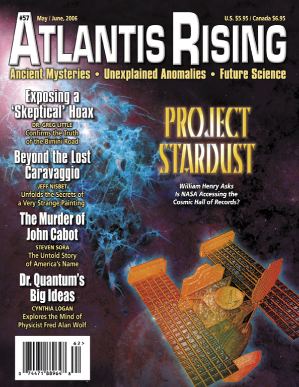
AR #57

Project Stardust
by William Henry

Posted on

How did Earth get its water?

This image has an empty alt attribute; its file name is ai-free.png

Our planet’s water could have originated from interactions between the hydrogen-rich atmospheres and magma oceans of the planetary embryos that comprised Earth’s formative years, according to new work from Carnegie Science’s Anat Shahar and UCLA’s Edward Young and Hilke Schlichting. Their findings, which could explain the origins of Earth’s signature features, are published in Nature.

For decades, what researchers knew about planet formation was based primarily on our own Solar System. Although there are some active debates about the formation of gas giants like Jupiter and Saturn, it is widely agreed upon that Earth and the other rocky planets accreted from the disk of dust and gas that surrounded our Sun in its youth.

As increasingly larger objects crashed into each other, the baby planetesimals that eventually formed Earth grew both larger and hotter, melting into a vast magma ocean due to the heat of collisions and radioactive elements. Over time, as the planet cooled, the densest material sank inward, separating Earth into three distinct layers—the metallic core, and the rocky, silicate mantle and crust.

However, the explosion of exoplanet research over the past decade informed a new approach to modeling the Earth’s embryonic state.

“Exoplanet discoveries have given us a much greater appreciation of how common it is for just-formed planets to be surrounded by atmospheres that are rich in molecular hydrogen, H2, during their first several million years of growth,” Shahar explained. “Eventually these hydrogen envelopes dissipate, but they leave their fingerprints on the young planet’s composition.”

Using this information, the researchers developed new models for Earth’s formation and evolution to see if our home planet’s distinct chemical traits could be replicated.

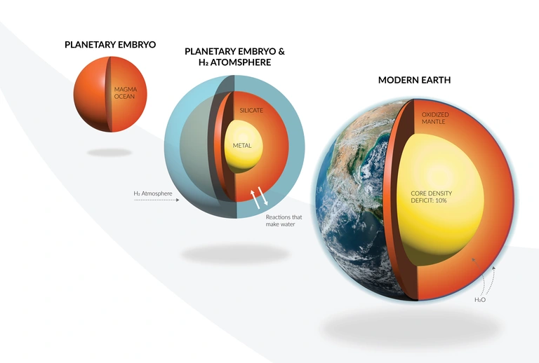
Using a newly developed model, the Carnegie and UCLA researchers were able to demonstrate that early in Earth’s existence, interactions between the magma ocean and a molecular hydrogen proto-atmosphere could have given rise to some of Earth’s signature features, such as its abundance of water and its overall oxidized state.  

The researchers used mathematical modeling to explore the exchange of materials between molecular hydrogen atmospheres and magma oceans by looking at 25 different compounds and 18 different types of reactions—complex enough to yield valuable data about Earth’s possible formative history, but simple enough to interpret fully.
Interactions between the magma ocean and the atmosphere in their simulated baby Earth resulted in the movement of large masses of hydrogen into the metallic core, the oxidation of the mantle, and the production of large quantities of water.


Caption: An illustration showing how some Earth’s signature features, such as its abundance of water and its overall oxidized state could potentially be attributable to  interactions between the molecular hydrogen atmospheres and magma oceans on the planetary embryos that comprised Earth’s formative years. Illustration by Edward Young/UCLA and Katherine Cain/Carnegie Institution for Science.


Even if all of the rocky material that collided to form the growing planet was completely dry, these interactions between the molecular hydrogen atmosphere and the magma ocean would generate copious amounts of water, the researchers revealed. Other water sources are possible, they say, but not necessary to explain Earth’s current state.
“This is just one possible explanation for our planet’s evolution, but one that would establish an important link between Earth’s formation history and the most common exoplanets that have been discovered orbiting distant stars, which are called Super-Earths and sub-Neptunes,” Shahar concluded.

This project was part of the interdisciplinary, multi-institution AEThER project, initiated and led by Shahar, which seeks to reveal the chemical makeup of the Milky Way galaxy’s most common planets—Super-Earths and sub-Neptunes—and to develop a framework for detecting signatures of life on distant worlds. Funded by the Alfred P. Sloan Foundation, this effort was developed to understand how the formation and evolution of these planets shape their atmospheres. This could—in turn—enable scientists to differentiate true biosignatures, which could only be produced by the presence of life, from atmospheric molecules of non-biological origin.

“Increasingly powerful telescopes are enabling astronomers to understand the compositions of exoplanet atmospheres in never-before-seen detail,” Shahar said. “AEThER’s work will inform their observations with experimental and modeling data that, we hope, will lead to a foolproof method for detecting signs of life on other worlds.”

AR #123

What Does Water Remember”

by Jeane Manning

Posted on

Deep Hidden ‘Structures’ Found on Moon’s Dark Side

Billions of years of lunar history revealed by Chinese rover

The Independent

This image has an empty alt attribute; its file name is ai-free.png

China’s Chang’e-4 mission rover has helped scientists visualize “hidden” structures deep below the surface of the moon’s far side. The Yutu-2 rover helped make the discovery through its Lunar Penetrating Radar (LPR) that imaged deep into the moon’s surface by listening to echoes of sound that bounced back off structures under the lunar surface and hidden from view.

The same rover and the mission’s lander had made history in 2019 as the first human objects to land on the far side of the moon – the side that faces away from the Earth. Scientists had previously used the rover’s ground penetrating radar (GPR), but those earlier efforts could help map only the top 40m, or about 130ft, of the moon’s surface. This new discovery has found the “hidden” structures at depths of about 300m (984ft).


The new data suggests the first 130 feet under the lunar surface is made up of layers of dust, soil, and rocks.
Radar analysis also revealed the presence of a buried crater that formed when a large object slammed into the lunar surface as well as helped map ancient lava flows under the moon.

“The GPR sends electromagnetic pulses into the lunar interior and receives echoes from subsurface layers. We use the high-frequency channel data to detect the structure of the upper 40 m along the rover’s path, primarily consisting of rock debris and soil,” researchers explained in the study.


Scientists speculate that the broken rocks surrounding this formation was likely debris produced by the impact.
The new study, published recently in the Journal of Geophysical Research: Planets, revealed lunar lava likely flowed across the landscape in this part of the moon billions of years ago (https://agupubs.onlinelibrary.wiley.com/doi/10.1029/2022JE007714).


Researchers found volcanic rock layers are thinner the closer they are to the lunar surface.

“The thickness variation of these lava flows suggests a decrease in eruption scale over time,” they noted.Based on this evidence, they said the lunar volcanic activity cooled gradually since the moon’s formation over 4.5 billion years ago, when a Mars-sized object slammed onto Earth and broke off a chunk that eventually coalesced into the moon.
“The thickness of the strata decreases with the decreasing depth, suggesting a progressively smaller lava effusion rate over time,” scientists concluded.

AR #129

What Could the Moon Be Hiding from Us

by William B. Stoecker

Posted on

China’s Qing Dynasty Collapse: Could it Be About to Happen Again?

by Rachael Funnell

This image has an empty alt attribute; its file name is ai-free.png

Those who forget history are condemned to repeat it, we have been told. Now, new research has identified three key drivers behind the collapse of the Qing Dynasty in China. Once an economy that was considerably wealthier in its time than modern-day China, it crumbled in 1912, and the proposed reasons behind it sound familiar.

Everything from environmental disasters to famines, uprisings, and foreign incursions have been held up as possible explanations for the collapse of such a superpower. However, Turchin and colleagues discovered that there were three key elements applying the most sociopolitical pressure.

According to a new study published in PLOS ONE, finding the key causes involved looking back at history through the lens of Structural Demographic Theory (SDT). The framework enables researchers to understand how big events like war and recession can shake up and destabilize a society. It’s useful in the modern era because it can help us better predict what events have the potential to have a catastrophic knock-on effect in the future, giving us time to try and mitigate the damage (https://journals.plos.org/plosone/article?id=10.1371/journal.pone.0289748).

The first driver behind the Qing Dynasty’s collapse was identified as a boom in the population, which increased fourfold between 1700 and 1840. This meant there was considerably less land for each person, which in economics is called “land per capita”, which we know affects rural communities the most as farming requires a lot of land if people are going to be able to support themselves.

The second driver was identified as increased competition for elite positions. It figures that if you have a boom in the number of people living in an area, the few positions of power available will find themselves inundated with potential applicants. We see it today in the job market, where hundreds of people may be applying for the same role, and the situation became particularly bleak for the Qing Dynasty by 1796. The lack of opportunities to rise into the bureaucratic ranks led to a crisis driven by a group of disgruntled elite wannabes known as aspirants.

“The big crisis was the Taiping Rebellion, probably the bloodiest civil war in human history,” Researcher Peter Turchin told IFLScience. “Tens of millions of people were killed.”

“The population of Qing Dynasty increased fourfold and there was just not enough productivity of the environment to feed them, but even more importantly, they had too many elite aspirants.”

With such catastrophic unrest comes vast expense, which leads us to the third and final key driver behind the Qing Dynasty’s collapse: the rising cost associated with the fallout. Between squashing unrest, reduced productivity, and a trade deficit brought on by depleting silver and opium, the Qing Dynasty found itself in financial chaos.

AR #56

Cycles of Danger

by William Hamilton